What is this mountain?
July 30, 2013 7:20 PM Subscribe
I got this print from a thrift store today. What mountain is it?
Yeah I'm pretty sure thats Mt. Fuji. Look at some of the profiles on this image search
posted by wildcrdj at 7:35 PM on July 30, 2013
posted by wildcrdj at 7:35 PM on July 30, 2013
Not Fuji, I don't think.
Krakatoa? Although Krakatoa seems to have a lot of different shapes.
posted by SLC Mom at 7:44 PM on July 30, 2013
Krakatoa? Although Krakatoa seems to have a lot of different shapes.
posted by SLC Mom at 7:44 PM on July 30, 2013
It's gotta be mount Fuji. That's what the picture screamed the minute I saw it and nothing I've googled has dissuaded me from that opinion. There's a reason its profile is so famous and revered.
posted by Justinian at 7:58 PM on July 30, 2013
posted by Justinian at 7:58 PM on July 30, 2013
I was judging by the bump on the left (like in these Mt. Fuji angles: here or here) and top but I can't be sure.
posted by wildcrdj at 8:00 PM on July 30, 2013
/fuji-san_2.jpg)
posted by wildcrdj at 8:00 PM on July 30, 2013
The only thing that really gives me pause is the lack of discernible snowcap which is typical of Fuji. But best guess is Fuji from across Lake Yamanaka.
posted by Justinian at 8:05 PM on July 30, 2013
posted by Justinian at 8:05 PM on July 30, 2013
Response by poster: We initially thought it was Fugi too, but I can't figure out what city would be in the foreground. I can't find any similar shots across a body of water with buildings in the immediate foreground. The mountain in the picture also seems to have a more rounded top than any pictures I can find of Fugi.
posted by quiet coyote at 8:14 PM on July 30, 2013
posted by quiet coyote at 8:14 PM on July 30, 2013
Mt. Fuji only has a snowcap in the winter.
posted by Confess, Fletch at 8:18 PM on July 30, 2013
posted by Confess, Fletch at 8:18 PM on July 30, 2013
The other theory is Krakatoa from Pulau? I dunno. You'd think it would be trivial to distinguish the two, and yet...
posted by Justinian at 8:59 PM on July 30, 2013
posted by Justinian at 8:59 PM on July 30, 2013
It might be near Yamanakako. That link lists some nearby towns as well.
Two reasons why you might not see other pictures from this angle: people may find including those sorts of buildings to be less aesthetically pleasing; and that area may have had different buildings before WW2, during occupation, after occupation, etc.
You can look around on street view and see if there is a similar angle.
posted by yohko at 9:10 PM on July 30, 2013
The more I look at it, I don't think it's Krakatoa/Krakatau, as there seems to be no land to build towns that are close enough to the island to produce that shot. The rounded top also seems to say old, not active volcano - if it's a volcanic mountain at all.
Now I really want to know too!
posted by gemmy at 9:29 PM on July 30, 2013
Now I really want to know too!
posted by gemmy at 9:29 PM on July 30, 2013
Stupid question: was it mounted in that frame when you bought it? Have you checked the back of the print to see if there's any writing on it?
posted by showbiz_liz at 9:41 PM on July 30, 2013
posted by showbiz_liz at 9:41 PM on July 30, 2013
Here's a drawing of the same view of Mt. Fuji. It includes a lake and town (but not the name of the town).
posted by Margalo Epps at 10:21 PM on July 30, 2013 [1 favorite]
posted by Margalo Epps at 10:21 PM on July 30, 2013 [1 favorite]
The top of the mountain looks much too rounded to be Fuji, plus those narrow ?three-storey buildings don't look Japanese. Maybe identifying what kind of buildings those are would be the key?
posted by runincircles at 11:26 PM on July 30, 2013 [1 favorite]
posted by runincircles at 11:26 PM on July 30, 2013 [1 favorite]
I think it's Fuji. The second photo on this page seems to have been taken from a similar angle; the ridges on each side of the mountain match and it may be that what looks like water in your photo is actually the huge field in the other photo.
posted by A Thousand Baited Hooks at 11:51 PM on July 30, 2013
posted by A Thousand Baited Hooks at 11:51 PM on July 30, 2013
FWIW, when I saw the picture my impression was Latin or South America. Also, the mountain looks much too small to be Fuji.
posted by barnacles at 1:19 AM on July 31, 2013
posted by barnacles at 1:19 AM on July 31, 2013
Based on the architecture, I have to vote for European (Mediterranean), or some colonial settlement.
The thing about the shape is that this is the general shape that a stratovolcano takes. The only real differences have to do with recent (i.e. holocene/historical) eruptions, or the erosion of at least thousands of years.
I agree this doesn't seem as large as Fuji, nor does it have the (commonly photographed) snowcap. That really looks like a body of water to me, so you need a volcano near water, with a settlement on the opposite shore (which may itself be on a bluff, although it's hard to tell precisely).
I also judge the era of this photo to be at least pre-WWII, although the quality could be this low anywhere in European colonial penumbra; if it's Europe the photograph would likely be earlier.
Then there's the perspective, which is high above this town -- possibly a very tall structure but more likely a hill of some type. Or, it could be from a balloon or airplane (accounting for diminished photographic quality).
posted by dhartung at 2:24 AM on July 31, 2013
I also get a Western Mediterranean/Latin American vibe from that town in the foreground. There are a lot of views like this in South America, particularly Nicaragua.
For example, here's Momotombo. Here's Concepcion.
posted by vacapinta at 4:20 AM on July 31, 2013
For example, here's Momotombo. Here's Concepcion.
posted by vacapinta at 4:20 AM on July 31, 2013
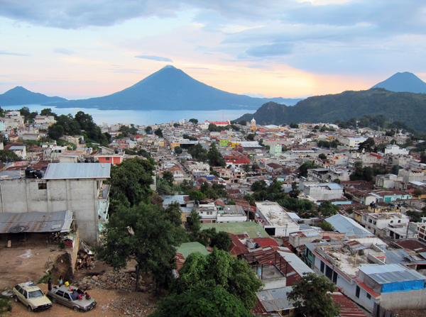
Best answer: I found it!!!
Look at the second photo on this page. Here's a direct link to the photo.
You can see everything matches up. Even the church belltower (yellow) and the bit of local mountain just to the right of it. The picture was taken from an elevation too. There's probably a hill back there.
The town is Solola, Guatemala. The volcano is San Pedro on Lake Atitlan.
posted by vacapinta at 7:48 AM on July 31, 2013 [14 favorites]
Response by poster: Whoah! Great work, vacapinta!!
posted by quiet coyote at 8:27 AM on July 31, 2013 [2 favorites]
posted by quiet coyote at 8:27 AM on July 31, 2013 [2 favorites]
Awesome! That certainly looks to be the correct location.
posted by gemmy at 8:29 AM on July 31, 2013
posted by gemmy at 8:29 AM on July 31, 2013
Great work, you can see the tower and everything in that photo
posted by J0 at 8:46 AM on July 31, 2013
posted by J0 at 8:46 AM on July 31, 2013
Yep, the towers are a dead giveaway! Nice work.
It's crazy how much some of these mountains look alike.
posted by Justinian at 8:52 AM on July 31, 2013 [1 favorite]
It's crazy how much some of these mountains look alike.
posted by Justinian at 8:52 AM on July 31, 2013 [1 favorite]
"Sololá is situated at 2.114 m on a mountainside overlooking Lake Atitlán, some 600 meters below."
I thought so! There's a photo there of the tower on the right-hand side, the "Torre Centroamericana", which seems to be visually famed in its own right. The third photo here reprises the same view as before. It's survived three earthquakes! Video (turn on English captions). It was built to commemorate the Central American Union (a defunct federal country on the Isthmus, but one which still held loyalty as a concept). What a picturesque place -- I want to go to there!
Anyway, Tolimán^ is the volcano we're looking at. There are no eruptions in the historical record.
posted by dhartung at 4:56 PM on July 31, 2013
Yes, dhartung is right. The volcano is Toliman. There are three volcanos around that lake. I had guessed it was San Pedro since the other two seem to be so close together. But, from the right angle, the one of the photo, Toliman stands apart from its twin Atitlan.
Actually, there are four volcanos. The fourth is Cerro de Orro. I think it is in the photograph too. It is small and sits in front of Toliman.
Interesting part of the world! Thanks for bringing it to our attention.
posted by vacapinta at 1:07 AM on August 1, 2013
Actually, there are four volcanos. The fourth is Cerro de Orro. I think it is in the photograph too. It is small and sits in front of Toliman.
Interesting part of the world! Thanks for bringing it to our attention.
posted by vacapinta at 1:07 AM on August 1, 2013
« Older "Afternoon Delight" ain't gonna cut it. | Tell me why do you want to leave your job after... Newer »
This thread is closed to new comments.
posted by LonnieK at 7:26 PM on July 30, 2013