Square these rocks
May 28, 2015 10:03 AM Subscribe
Geometric rock formations in West Virginia river. How did they form?
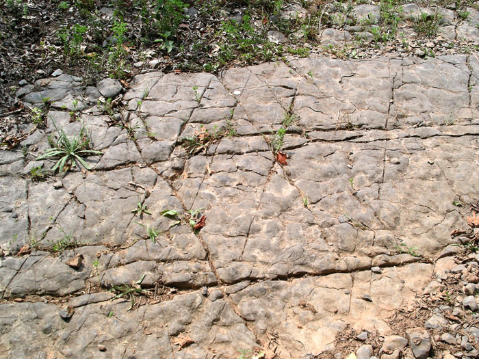
A friend took me and a friend hiking in West Virginia, close to Elkins. We were crossing a foot bridge and saw these square and diaganol rock formations in the riverbed. My knowledge of geology is very limited, but I can't figure out how these consistent square formations could form. I assume something involving weaker areas in the rock washing away, but how does that happen in a pattern?
Pic 1
pic 2
No, nature loves right angles, so much that these kinds of joints have a specific name. Those are systematic orthogonal joint systems in (what appears to be) limestone, sometimes called a tessalated pavement. Systematic means that there are multiple joints parallel to each other. Orthogonal means the joints are set 90 degrees to each other. In this case, one set in one direction is probably from tectonic stress which caused brittle breakage of the rock from tensile stresses - i.e. stretching the rock until it broke perpendicular to the direction the rock was being stretched. In WV this probably was one of the three mountain building events that left the Appalachian chain (those are the Alleghanian (260 mya) , Acadian (375 mya) and Taconic (440 mya). With nothing but location I'm gonna guess that it was either the Acadian or Taconic. Tectonic joints can be hundreds of miles long sometimes, and are often a good clue a mountain range existed in an area even when the mountains disappeared hundreds of millions of years ago.
The second, perpendicular set could be hypothesized to be "release" or "unloading" joints, which occur when sedimentary rocks are brought to the surface during uplift - as they uplift they cool and contract, building stress that fractures the rock perpendicular to the tectonic stress joints. Or they could be from another tectonic event in which stress was placed from a different direction, but when you have joint sets perpendicular so neatly it's usually one set from tectonics and the other from unloading. (That's the 101 explanation, in reality it can be quite complex).
Fracturing can also be a result of pore pressure buildup, when pore water is trapped in the rock with nowhere to go; if enough pressure from an accumulation of overlying sediments builds it may "break out". If you look carefully at the picture there are also some diagonal joints, which could be a result of other regional stress or pore pressure buildup. Those joint sets can be a variety of geometries depending on where the pressure was occurring. "Diagonal" or about 30-60 degree joint systems are called conjugate systems.
So, basically, at some point stress caused the rock to break. The "breakage" zone could have been filled with water or minerals, causing an easily erodible surface when it finally became exposed. Also, brittle deformation, or breakage, like that tends to occur when rocks are relatively shallow to the earth's surface. How the rocks break and where depends on the composition of the rock, including how lithified (how hardened) it is, if it has features in it from its deposition (a coral reef breaks differently than sand deposited in a river), if it has water or other fluids in its pore spaces, and its direct composition - the minerals in sand, silt, clay, granite will break in different ways. The first, initial pressure - probably tectonic since it's so regular - than influenced other brittle deformation
Planar fractures tend to be along bedding planes with some displacement; from the picture it looks like you may have been standing on the bedding plane itself - although, with limestone, "bedding plane" is a term with many definitions - so I wouldn't call these planar fractures. A bedding plane is essentially a layer of deposition, though not always horizontal. You can see the bedding plane disappear into the distance downstream (?) where it would be covered by younger rock.
posted by barchan at 12:51 PM on May 28, 2015 [13 favorites]
Some types of rocks do naturally tend towards certain geometric shapes because of the manner in which the molecules adhere. Quartz comes to mind. So it is possible that is natural, ala these natural rock formations. But I also think it looks manmade. My impression is that river and creek beds are sometimes cut in order to do prep work for nearby bridges and the like. I have often seen similar cuts in creeks as I walk over bridges in California. I would consider that possibility in this case first.
posted by Michele in California at 1:08 PM on May 28, 2015 [1 favorite]
posted by Michele in California at 1:08 PM on May 28, 2015 [1 favorite]
Take a look at the Giant's Causeway in Northern Ireland:
Horizontal examples of such formations are known, I've read, and glaciers could grind them flat, but West Virginia had no ice-sheet coverage during the last glacial maximum, apparently.
posted by jamjam at 1:23 PM on May 28, 2015
In the Causeway rock, the overall jointing pattern (columnar joints), is primarily due to shrinkage of the semi-solid interior of the lava flow after cooling. The internal stresses induced by thermal contraction on horizontal surfaces lead to the formation of vertical and approximately parallel columnar joints.If you turned this kind of formation (aka 'devil's postpile') onto its side and planed it flat, it would look a lot like that riverbed.
Horizontal examples of such formations are known, I've read, and glaciers could grind them flat, but West Virginia had no ice-sheet coverage during the last glacial maximum, apparently.
posted by jamjam at 1:23 PM on May 28, 2015
barchan has it right. Here's a regionally-relevant similar example, from this page. Description:
"Shown above is an irregular bedding surface from the lower Helderberg at Cave Mountain typical of carbonates formed by algal mats. Because they are generated by living marine organisms, such surfaces are only roughly conformable to the sea floor. Different portions of the mat grow at different rates giving the mat an irregular, wrinkled topography consisting of small hills and valleys. Also visible on this surface are a series of regular shaped fractures or joints that formed long after the algal mats were turned into rock. The orientation of the joints indicates that the direction of maximum compression of the rocks in this photograph is from top (west) to bottom (east)."
posted by late afternoon dreaming hotel at 1:28 PM on May 28, 2015 [1 favorite]
This thread is closed to new comments.
posted by jmsta at 12:38 PM on May 28, 2015 [1 favorite]