High-res color day/night visible satellite images?
December 20, 2005 6:12 PM Subscribe
Where can I get high-res color visible satellite images showing the approach of "night" (sample low-res link inside)?
Here's the low-res version (from weather underground) of what I'm looking for:
http://antinomian.com/trans/satBanner.jpg
Any idea where I can get a version suitable for printing or at least desktop wallpaper? I've looked around a bit and found some high-res stuff that is monochrome or has the "dark" portion totally blacked out e.g. http://antinomian.com/trans/blackedOut.jpg but that's not nearly so neat looking, IMHO.
NASA's Visible Earth Project
They have high resolution (actually, HUGE is a better word) composites of satellite imagery.
Look around and you'll find more than you'll probably need
posted by sd at 7:21 PM on December 20, 2005
They have high resolution (actually, HUGE is a better word) composites of satellite imagery.
Look around and you'll find more than you'll probably need
posted by sd at 7:21 PM on December 20, 2005
For example:
http://veimages.gsfc.nasa.gov//1438/earth_lights.jpg
(From http://visibleearth.nasa.gov/view_rec.php?id=1438, where it's also available as a 30,000 x 15,000 GIF image)
posted by sd at 7:22 PM on December 20, 2005
http://veimages.gsfc.nasa.gov//1438/earth_lights.jpg
(From http://visibleearth.nasa.gov/view_rec.php?id=1438, where it's also available as a 30,000 x 15,000 GIF image)
posted by sd at 7:22 PM on December 20, 2005
Best answer: C'mon, people, don't make me cut-n-paste those urls.
http://antwrp.gsfc.nasa.gov/apod/ap030324.html
http://antwrp.gsfc.nasa.gov/apod/ap970830.html
http://antwrp.gsfc.nasa.gov/apod/ap050611.html
http://antwrp.gsfc.nasa.gov/apod/ap040822.html
http://veimages.gsfc.nasa.gov//1438/earth_lights.jpg
(From http://visibleearth.nasa.gov/view_rec.php?id=1438, where it's also available as a 30,000 x 15,000 GIF image)
posted by ryanrs at 7:32 PM on December 20, 2005 [1 favorite]
lol! Thanks, ryanrs.
I might add that the living earth page is continuously updated to show the *real time* position of night on the globe. Remember, sd, it's not always about size, but how you use it.
Do I get bonus points now?
posted by Jonasio at 7:55 PM on December 20, 2005
I might add that the living earth page is continuously updated to show the *real time* position of night on the globe. Remember, sd, it's not always about size, but how you use it.
Do I get bonus points now?
posted by Jonasio at 7:55 PM on December 20, 2005
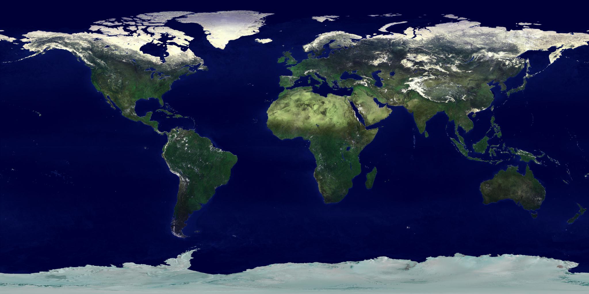
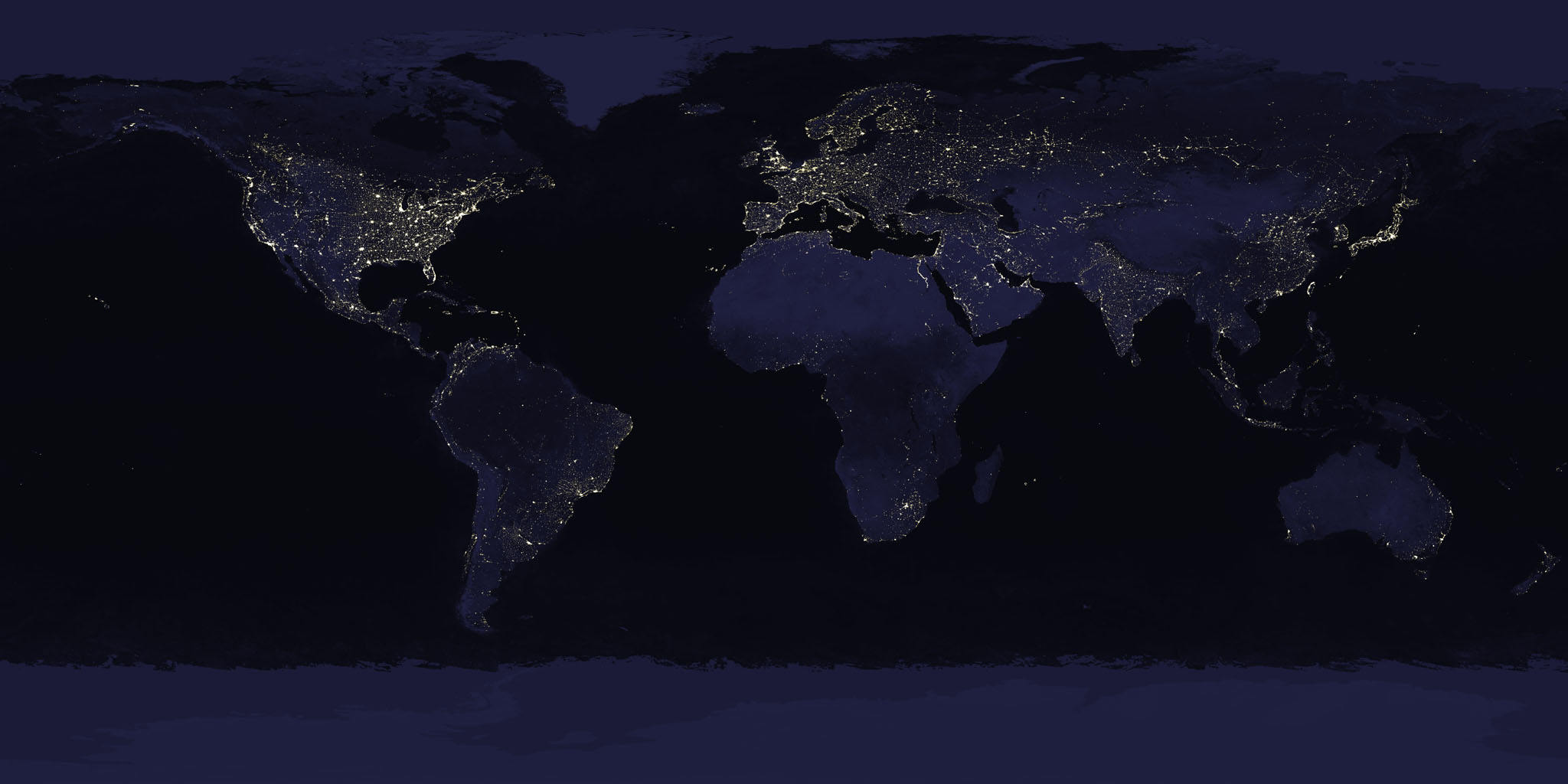
Looking through sd's NASA's Visible Earth Project link, I found a pair of day/night images with perfect alignment. The day image is a color topo map with no borders or contours. The night image shows land masses in very dark blue with bright white city lights. These are very nice images. They're available as TIFs in two sizes.
2048x1024:
topo 1.9MB
night 1.2MB
8192x4096:
topo 26.5MB
night 10.3MB
posted by ryanrs at 7:58 PM on December 20, 2005
2048x1024:
topo 1.9MB
night 1.2MB
8192x4096:
topo 26.5MB
night 10.3MB
posted by ryanrs at 7:58 PM on December 20, 2005
Best answer: Really there aren't many satellites that watch the transition of day to night since major earth observation satellites usually travel in sun synchronous orbit in order to have their scenes fully lit all times. The goes weather satellites are probably your best bet for an actual view of the transition of day to night, but only have about 1km spatial resolution and are tuned to observe the atmosphere, not the land below.
So basically all I am saying is that all of the above links are showing conceptualized views of the transition, not actual observations (with this exception)
posted by jduckles at 7:59 PM on December 20, 2005
So basically all I am saying is that all of the above links are showing conceptualized views of the transition, not actual observations (with this exception)
posted by jduckles at 7:59 PM on December 20, 2005
Best answer: BTW, those images I posted have very liberal Terms of Use. An excerpt:
posted by ryanrs at 8:15 PM on December 20, 2005
For all non-private uses, NASA's Terms Of Use are as follows:jduckles: yes, these images are composites from different satellites.Visible Earth Addendum
- The imagery is free of licensing fees
- NASA requires that they be provided a credit as the owners of the imagery
Beyond the NASA Terms, the Visible Earth team requests, but does not require:
- The Visible Earth be provided a credit as the location that the imagery was found at
- A URL be provided, either to the Visible Earth (http://visibleearth.nasa.gov/) or to the page providing the link to the used image.
posted by ryanrs at 8:15 PM on December 20, 2005
Response by poster: Wow, these are all great answers. I was even contemplating asking about the whole issue of composite images vs. images from a single source (but decided against, since I didn't want to unnecessarily complicate the question) and I got all kind of info on that subject anyway!
posted by idontlikewords at 8:33 PM on December 20, 2005
posted by idontlikewords at 8:33 PM on December 20, 2005
Jonasio, I just noticed that your Earth View link has an option to use the NASA imageset I posted earlier. Earth View/NASA. But what makes it really awesome is the detailed explanation and full source code.
posted by ryanrs at 8:39 PM on December 20, 2005
posted by ryanrs at 8:39 PM on December 20, 2005
Best answer: I use a screen saver called XPlanet in Linux. Lots of good links from their maps page. I have it configured currently to take this daytime image, this night image, and this cloud-cover image (that I download every three hours) and make a 3d image of the earth as it is approximately currently lit.
posted by Plutor at 7:13 AM on December 21, 2005
posted by Plutor at 7:13 AM on December 21, 2005
This thread is closed to new comments.
http://antwrp.gsfc.nasa.gov/apod/ap030324.html
http://antwrp.gsfc.nasa.gov/apod/ap970830.html
http://antwrp.gsfc.nasa.gov/apod/ap050611.html
http://antwrp.gsfc.nasa.gov/apod/ap040822.html
A few years ago, I saw a fantastic composite picture of the entire earth, projected into a flat map, and the day-night line was shaped like a sine wave across the planet's surface. If I could only find that pic again.....
posted by Jonasio at 6:46 PM on December 20, 2005