Speed limit: 1 minute per hour
September 7, 2011 3:14 PM Subscribe
Where can I find a map that shows driving distance instead of just physical distance?
It would probably be too hard to redraw a map where 1 inch = 1 minute, due to the havoc caused by freeways and slower roads.
But I'm hoping to find something like Google maps where you put an address and it draws concentric circles of driving time around that address, or better yet, colors the entire map along a spectrum based on driving time, e.g. blue is really close and it shifts to green, orange and then red, being the farthest.
Or maybe there's a painless way to calculate this for myself?
Upon further examination, Mapificiant I think is focused on public transit, not driving time.
posted by RobotHero at 3:21 PM on September 7, 2011
posted by RobotHero at 3:21 PM on September 7, 2011
Google Maps does this.
Punch in an address and hit Enter. On the left side, under the address you punched in, click Directions. Punch in the other address and hit Enter. The drive time is listed right there.
posted by Sys Rq at 3:21 PM on September 7, 2011
Punch in an address and hit Enter. On the left side, under the address you punched in, click Directions. Punch in the other address and hit Enter. The drive time is listed right there.
posted by Sys Rq at 3:21 PM on September 7, 2011
Response by poster: @Sys Rq: I'm not looking for how to find the driving time between point A and point B. I'm trying to find the driving time between point A and every other point on the map.
posted by brenton at 3:24 PM on September 7, 2011
posted by brenton at 3:24 PM on September 7, 2011
Response by poster: @Admiral Haddock: wow that's exactly what I'm looking for, if only it weren't public transportation! I want something just like that for cars!
posted by brenton at 3:28 PM on September 7, 2011
posted by brenton at 3:28 PM on September 7, 2011
brenton, it looks like you can select slow cars and fast cars as an option on that link.
posted by reductiondesign at 3:32 PM on September 7, 2011
posted by reductiondesign at 3:32 PM on September 7, 2011
Response by poster: @Admiral & Reductiondesign: very neat and useful tool. This is pretty close to what I want, though it's too bad that it assumes that you just have a flat-rate of speed, and doesn't calculate varying road speeds and stoplights like Google maps does.
posted by brenton at 3:38 PM on September 7, 2011
posted by brenton at 3:38 PM on September 7, 2011
I think my link does do that for cars (albeit in metric, so you have to convert it to miles).
posted by Admiral Haddock at 3:38 PM on September 7, 2011
posted by Admiral Haddock at 3:38 PM on September 7, 2011
Should have previewed. You're right, it is a bit blunt a tool in that regard.
posted by Admiral Haddock at 3:39 PM on September 7, 2011
posted by Admiral Haddock at 3:39 PM on September 7, 2011
You could search for "isochrone map." (Too busy to do this now, apologies.)
posted by carter at 4:05 PM on September 7, 2011
posted by carter at 4:05 PM on September 7, 2011
If you want to help build it, I'm working on a general purpose trip planner which will eventually support isochrone mapping (there was a post on our developers mailing list about it in the past couple of days). The project is OpenTripPlanner. It presently only barely supports cars (no speed limits; no left turn a bit broken in the presence of transit), but that would be relatively easy to change (especially if you don't care about drive-to-transit).
posted by novalis_dt at 4:17 PM on September 7, 2011
posted by novalis_dt at 4:17 PM on September 7, 2011
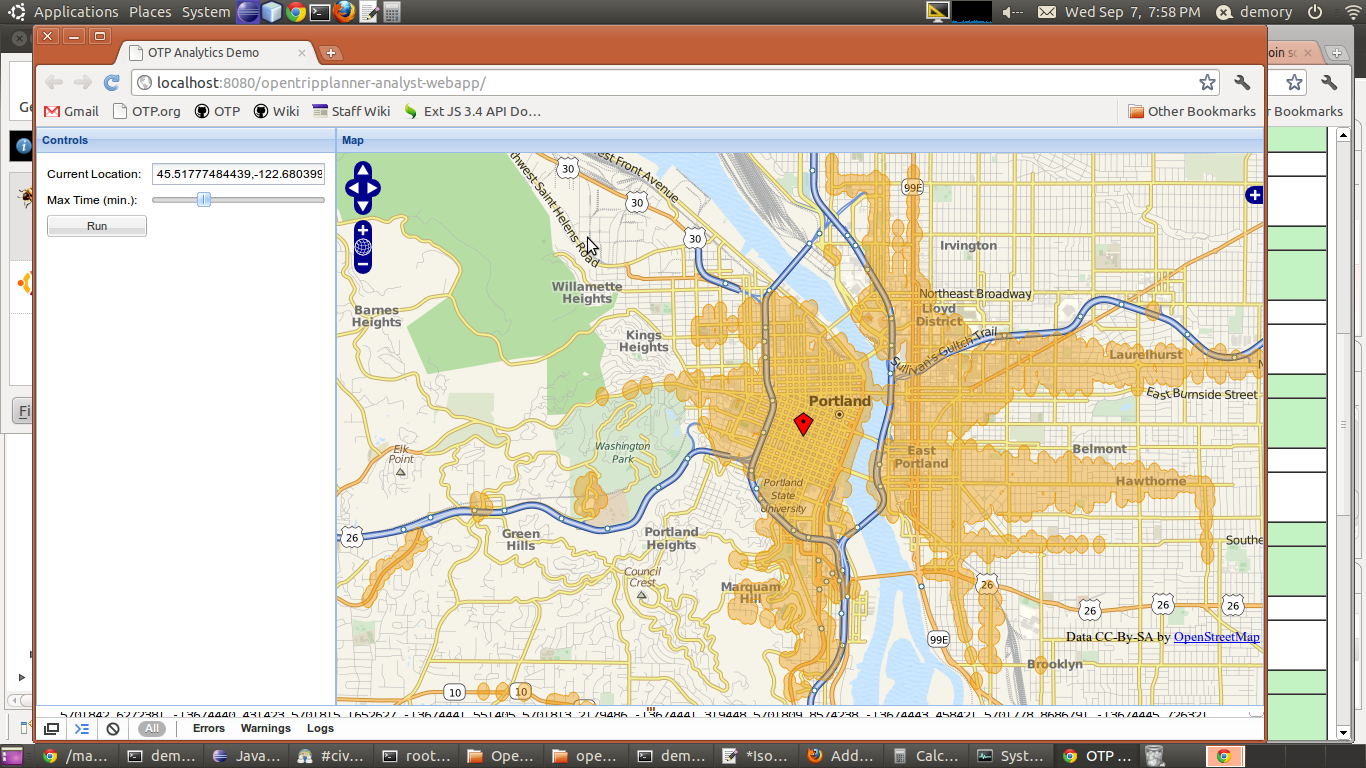
Just after I posted this, my colleague called me over to show me a demo of the isochrone code; I begged him to send me a screenshot and he did. It's just a demo, and of course shows transit rather than driving times, but it's a start.
posted by novalis_dt at 5:03 PM on September 7, 2011
posted by novalis_dt at 5:03 PM on September 7, 2011
Response by poster: @novalis looks awesome, be sure to post a link to it here when you finish the project. If you do get it to work with cars and to take into consideration all the driving considerations then it will be just amazing. I see that it works with a slider right now, which is great. If you want to really make it awesome, you'll consider developing an option that will automatically calculate out a bunch of different "max times" on your scale within a range and overlay them, displayed in a gradient of colors. For example: 0mins , 5mins, 10mins, 15mins, 20mins. (increment: 5, range: 0-20.) Do you need a HTML/CSS/Javascript guru on the project?
posted by brenton at 6:10 PM on September 7, 2011
posted by brenton at 6:10 PM on September 7, 2011
What you're describing reminds me of a feature in Padmapper. I think this might be what you're looking for?
Unlike other sites I've found, it seems to take actual driving conditions into account (i.e., you can travel a greater distance in 10 minutes on a freeway than in 10 minutes on a neighborhood street).
posted by texano at 6:50 PM on September 7, 2011
Unlike other sites I've found, it seems to take actual driving conditions into account (i.e., you can travel a greater distance in 10 minutes on a freeway than in 10 minutes on a neighborhood street).
posted by texano at 6:50 PM on September 7, 2011
Best answer: In a previous thread, mefi's awesome GIS guru desjardins currently on a road trip posted this driving time mapper based on GMaps.
posted by dhartung at 9:58 AM on September 8, 2011
posted by dhartung at 9:58 AM on September 8, 2011
This thread is closed to new comments.
http://flowingdata.com/2011/06/01/find-everywhere-you-can-go-in-15-minutes-or-less/
posted by RobotHero at 3:19 PM on September 7, 2011 [1 favorite]