Identify this geographic feature.
March 25, 2006 1:00 PM Subscribe
What is this?
It looks like a lake, but there's no labels on Google Maps, or roads leading to it. Anyone know?
It looks like a lake, but there's no labels on Google Maps, or roads leading to it. Anyone know?
Best answer: google earth says "deep springs lake"
posted by ROU_Xenophobe at 1:05 PM on March 25, 2006
posted by ROU_Xenophobe at 1:05 PM on March 25, 2006
Looks like a lake inside of a volcano crater that is frozen over
posted by Justin Case at 1:08 PM on March 25, 2006
posted by Justin Case at 1:08 PM on March 25, 2006
Mono lake is due North West. Zoom out and you can see it.
posted by Who_Am_I at 1:17 PM on March 25, 2006
posted by Who_Am_I at 1:17 PM on March 25, 2006
It does look like this pic of Deep Springs Lake though.
posted by Who_Am_I at 1:21 PM on March 25, 2006
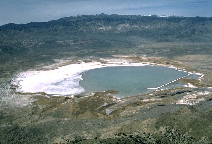
posted by Who_Am_I at 1:21 PM on March 25, 2006
Deep Springs is correct. Sorry for the false Mono suggestion.
posted by syzygy at 1:26 PM on March 25, 2006
posted by syzygy at 1:26 PM on March 25, 2006
I'm pretty sure it's a small, volcanic lake. Lake Tahoe is similar and is very, very deep. Crater Lake in Oregon is another example.
There are lots more around the Tahoe region, and many of them probably aren't labeled via Google Maps. It's also possible that this lake is temporary - existing only in the summer months due to runoff. If you get a good USGS map of the region you'll probably see it just fine.
posted by aladfar at 1:33 PM on March 25, 2006
And the smaller green patch to the NNE is Deep Springs College. The lake, from what I remember, is seasonal.
posted by Johnny Assay at 3:03 PM on March 25, 2006
posted by Johnny Assay at 3:03 PM on March 25, 2006
Response by poster: OK, topozone may be the coolest thing I've seen all day. Thanks for the answers!!
posted by salad spork at 3:34 PM on March 25, 2006
posted by salad spork at 3:34 PM on March 25, 2006
This thread is closed to new comments.
posted by muddgirl at 1:05 PM on March 25, 2006