deciphering survey notations
April 1, 2015 8:56 AM Subscribe
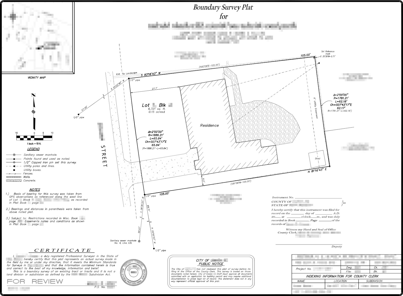
Can any surveyor Mefites out there help me understand the notations on this survey?
Image has been anonymized (locations/names). Specifically, in plain English, what do the 2 blocks of text at the front and back property boundaries mean?
Front:
∆=2°00'00"
R=1866.21'
L=65.84'
Ch=S07°43'17"E
65.84'
(R=1866.21'–L=65.84')
Back:
∆=2°00'00"
R=1781.21'
L=62.18'
Ch=S07°43'17"
62.17
R=1781.21'–L=62.18'
Also, anything else interesting/of note? Am I correct in reading that the property boundary doesn't include the entire front yard up to the sidewalk? Thanks!
That is the curve data for the property line - the lines at the front and back of the property are actually curves and not straight lines.
The delta is the amount the 2 tangent lines differ in degrees, R is the radius, L the actual length of the curve. I’m not sure what the Ch is.
And you are correct about the property line, the additional area outside of the property line up to the street is usually right of way owned by the municipality that the property is located in.
posted by Sabby at 9:16 AM on April 1, 2015
delta=2 degrees refers to the section of a full circle this arc represents. In other words, those curved boundaries represent 2/360ths of a full circle. You can see by the orientations of the north and south boundaries that they diverge by two degrees.
Ch is probably the orientation of a straight line drawn between the two corners.
posted by beagle at 9:42 AM on April 1, 2015
Ch is probably the orientation of a straight line drawn between the two corners.
posted by beagle at 9:42 AM on April 1, 2015
Ch is probably the orientation of a straight line drawn between the two corners.
Yep. Ch is Chord, and the numbers are the bearing (7 degrees, 43 minutes, 17 seconds east of a line heading true south), and length, 65.84'.
posted by hwyengr at 9:45 AM on April 1, 2015
Yep. Ch is Chord, and the numbers are the bearing (7 degrees, 43 minutes, 17 seconds east of a line heading true south), and length, 65.84'.
posted by hwyengr at 9:45 AM on April 1, 2015
Ch is the bearing of the Long Chord between the endpoints of the curve. The radius of this curve is so large that the Middle Ordinate (distance from the midpoint of the curve to the midpoint of the LC) is about 3.5". This Army field manual has some good definitions if you really want to get into it.
posted by Uncle Jimmy at 9:51 AM on April 1, 2015
posted by Uncle Jimmy at 9:51 AM on April 1, 2015
Also, anything else interesting/of note?
Your shed is on a utility easement, so it's possible that some time in the future the utility company will ask you to move it so they can maintain or install additional infrastructure.
posted by hwyengr at 9:52 AM on April 1, 2015
Your shed is on a utility easement, so it's possible that some time in the future the utility company will ask you to move it so they can maintain or install additional infrastructure.
posted by hwyengr at 9:52 AM on April 1, 2015
It looks like they found three existing property pins, which is pretty good. Also, there are two utility lines running to a utility box in the northeastern corner of the lot. It's not indicated exactly what they are and if those lines are observed or presumed or..?
It's very common for the actual property line to cross over what you think of as "my lawn." In your case it feels to me like you're responsible for an especially generous portion of RoW.
posted by werkzeuger at 12:54 PM on April 2, 2015
It's very common for the actual property line to cross over what you think of as "my lawn." In your case it feels to me like you're responsible for an especially generous portion of RoW.
posted by werkzeuger at 12:54 PM on April 2, 2015
« Older Recipes to use Patak's curry paste | Appointment(s) with new dentist: is this normal? Newer »
This thread is closed to new comments.
No, the sidewalk and part of the front yard are not on the property, which is typically the case.
posted by humboldt32 at 9:14 AM on April 1, 2015