Shooting the drought in CA
January 22, 2015 1:45 PM Subscribe
Hi,
I'm headed out to CA over the weekend. I going to be in the Sacramento, San Jose, Fresno, and LA
areas over the course of a week. I'm looking to shoot video for a piece I am doing about the drought. I was wondering if there are any locals that might suggest some places to look compelling images.
Thanks!
I grew up in Fresno - I sent you a memail.
Head out toward Woodward Park & Friant Dam.
posted by jrobin276 at 2:09 PM on January 22, 2015
Head out toward Woodward Park & Friant Dam.
posted by jrobin276 at 2:09 PM on January 22, 2015
You could check out some of the spots mentioned in this long piece on the San Joaquin River (which was linked on the blue). They're not exactly in the cities you mention but if you are driving between them, the stuff in the central valley is on the way.
posted by exogenous at 2:16 PM on January 22, 2015
posted by exogenous at 2:16 PM on January 22, 2015
The California State Capitol stopped watering their lawns and had drought support signs on the brown/dead grass. The grass might be a little greener with the rain we had in December, and I'm not sure if the signs are still there, but you might go by and take a look.
posted by cnc at 2:31 PM on January 22, 2015
posted by cnc at 2:31 PM on January 22, 2015
Best answer: Go to Lake Oroville. We were camping there over Thanksgiving and it's... startling. If you head to the upstream sections of each of the branches of the Feather River, old roads emerge that you can walk down into valleys that have been under 200 or so feet of water for decades. For example, near the Lime Saddle campground, park in this lot. See the boat ramp along the right side of it? That used to be a road, which you can now follow to the valley floor--some of the road stripe paint has even survived. Plus, since all the trees and soil have been stripped away, you can see all the amazing geology laid bare. Here's a smattering of my lazy phone pics from that spot (it'd be kinda cool to see how these views have changed since we got a bunch of rain in December but have been back to savagely parched since then).
posted by late afternoon dreaming hotel at 2:42 PM on January 22, 2015
posted by late afternoon dreaming hotel at 2:42 PM on January 22, 2015
Mono frickin' Lake. It's been pretty alarming-looking from the air.
posted by gusandrews at 2:45 PM on January 22, 2015
posted by gusandrews at 2:45 PM on January 22, 2015
Thanks to the rains we had in December, Folsom Lake is actually somewhat close to where it would normally be this time of year, but other reservoirs are still pretty low.
posted by ckape at 3:52 PM on January 22, 2015
posted by ckape at 3:52 PM on January 22, 2015
If you are going to be driving between San Jose and Fresno (or if you are going to be driving between Sacramento and Fresno on I-5), make a swing by giant San Luis Reservoir (GIS search results), which is located on CA State Hwy 152, about 3 miles from I-5. If you are driving between San Jose and Fresno you will likely pass right by it. It's a huge reservoir that, like Lake Oroville to the north, is one of the major pillars in CA's system of moving water from Northern CA to Southern CA. It is below its historic average for this time of year, and due to its size and huge infrastructure (big dam, big pipes, etc.) it photographs well.
posted by mosk at 4:07 PM on January 22, 2015
posted by mosk at 4:07 PM on January 22, 2015
It might also be worth going up into the mountains, which ought to be covered in snow but are not. Most of northern California's water comes from melted snowpack, and lately we haven't had a snowpack.
posted by xeney at 4:16 PM on January 22, 2015
posted by xeney at 4:16 PM on January 22, 2015
Lake Shasta is further up but definite for a great illustration of man made solutions dealing with environmental conditions.
posted by parmanparman at 4:32 PM on January 22, 2015
posted by parmanparman at 4:32 PM on January 22, 2015
We went by San Luis Reservoir about a month ago and while it's lower than normal, it's not shockingly so like the Folsom or Oroville reservoirs. But if you're passing by on 5, might as well take a look. There are a few boat launch ramps that end far above the water line.
posted by zsazsa at 4:50 PM on January 22, 2015
posted by zsazsa at 4:50 PM on January 22, 2015
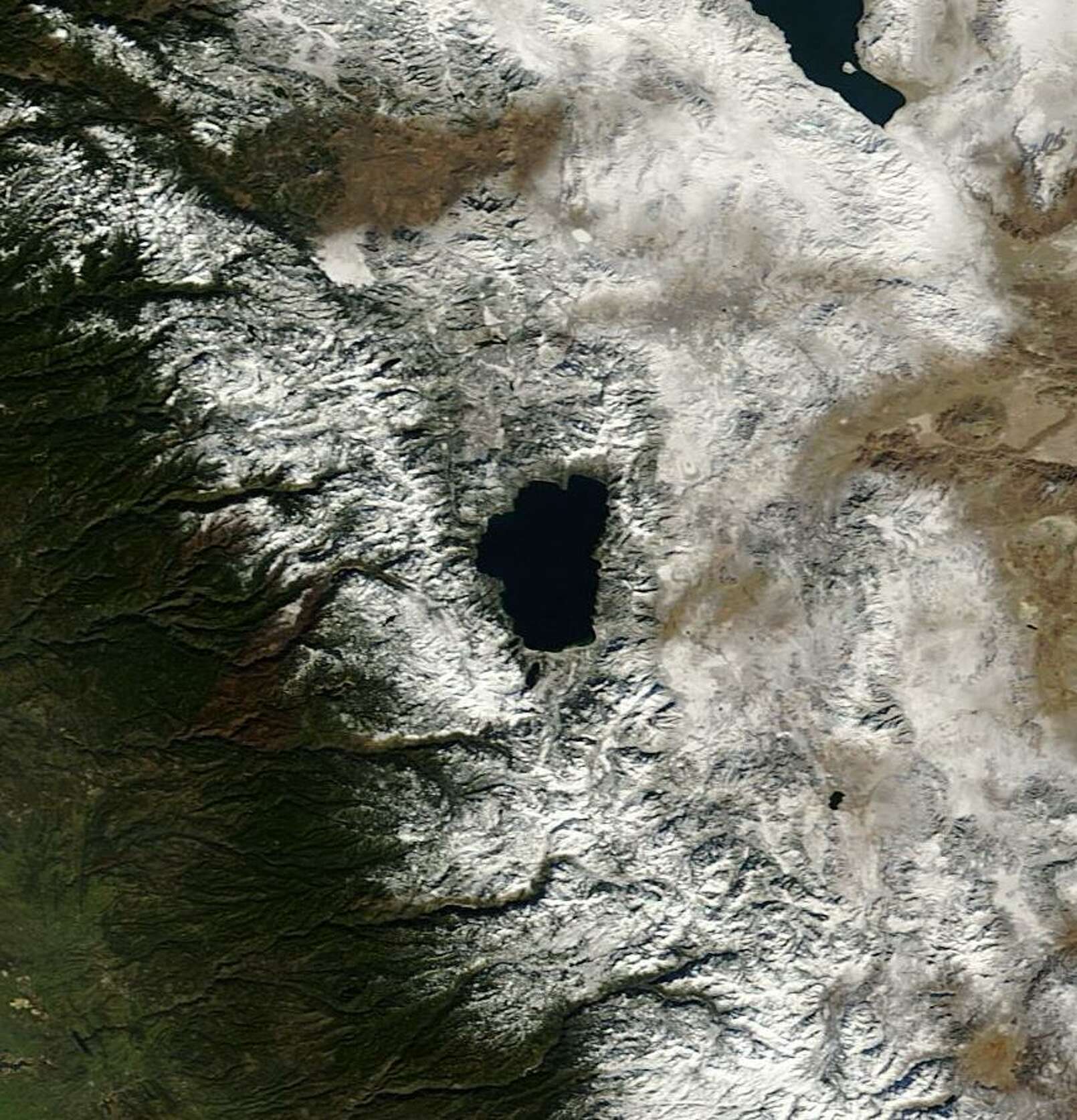
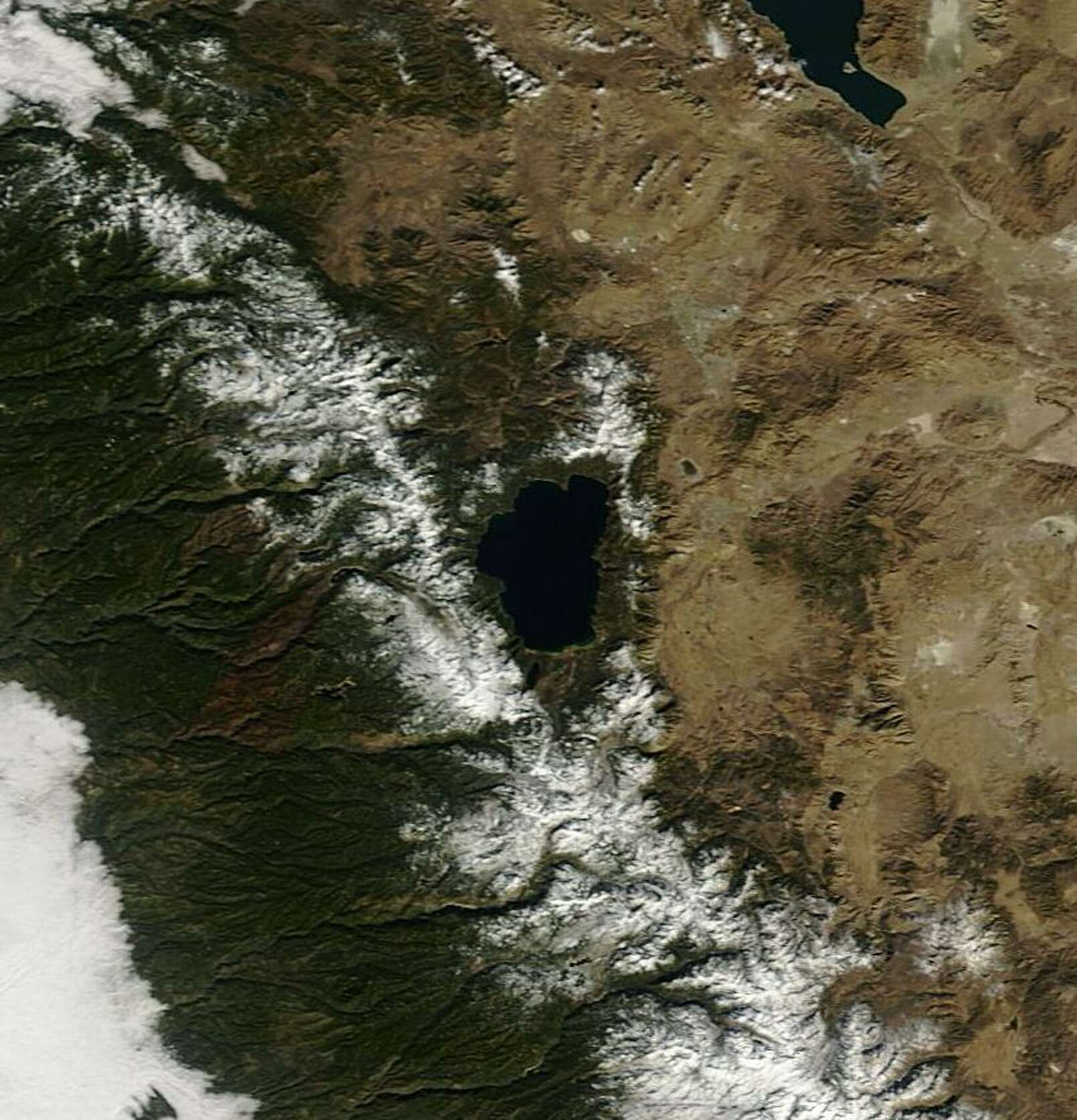
These may not suggest a particular place to take photos, but they may be useful in their own right. These two photos appeared today accompanying a SF Chronicle story about the current light snow pack in the Sierras and how our warm and dry January is impacting California ski resorts. The Chronicle story is behind a paywall, so linking to it may be futile for you, but these NASA Worldview satellite photos of Lake Tahoe and its surroundings illustrate what's happened in California and Nevada just since January 1 of this year:
Photo 1 (photographed 01/01/2015)
Photo 2 (photographed 01/19/2015)
posted by mosk at 4:54 PM on January 22, 2015 [2 favorites]
Photo 1 (photographed 01/01/2015)
Photo 2 (photographed 01/19/2015)
posted by mosk at 4:54 PM on January 22, 2015 [2 favorites]
Here's that SF Chronicle story on SFGate.
posted by potsmokinghippieoverlord at 5:41 PM on January 22, 2015
posted by potsmokinghippieoverlord at 5:41 PM on January 22, 2015
Came in to nth San Luis Reservoir on Highway 152 - the water level has dropped so dramatically that you will likely get some striking images of the striations.
posted by Ink-stained wretch at 7:15 PM on January 22, 2015
posted by Ink-stained wretch at 7:15 PM on January 22, 2015
Drive down the 5 to get shots of miles of Ag sucking up the water and also the signs on the side of the road with statements like: "There is no bad drought, only bad politics" and "F* Barbara Boxer" - I'm paraphrasing, but the 5 is where the drought meets the political and it is pretty interesting.
posted by Toddles at 7:24 PM on January 22, 2015
posted by Toddles at 7:24 PM on January 22, 2015
If you're in the Bay Area, the last time I headed over to Stevens Creek Reservoir, the water level was so low most of the bottom of the reservoir was dry.
posted by phoebus at 1:36 AM on January 23, 2015
posted by phoebus at 1:36 AM on January 23, 2015
This has items revealed by low water levels in reservoirs.
http://www.sfgate.com/outdoors/article/Drop-in-lake-water-levels-exposes-history-5217849.php
posted by gryftir at 2:13 AM on January 23, 2015
http://www.sfgate.com/outdoors/article/Drop-in-lake-water-levels-exposes-history-5217849.php
posted by gryftir at 2:13 AM on January 23, 2015
Response by poster: Thanks everyone! This is extremely helpful!
posted by Shanachie at 7:16 AM on January 23, 2015
posted by Shanachie at 7:16 AM on January 23, 2015
Folsom Lake (east of Sacramento) has receded significantly, enough to uncover the former gold mining town of Mormon Island. You can find out more info on Mormon Island's uncovering here
posted by knolan at 10:24 PM on March 11, 2015
posted by knolan at 10:24 PM on March 11, 2015
This thread is closed to new comments.
posted by sunset in snow country at 1:55 PM on January 22, 2015 [1 favorite]